We’d like to invite you to attend a public talk by Anastassia Vybornova from the IT University of Copenhagen on the topic of ‘Mathematics in the Ghetto’: pitfalls (and potentials) of computational approaches to urban segregation, that will happen on December 4th at the Faculty of Science.
Anastassia Vybornova (she/her) is a PhD student in Urban Data Science at IT University of Copenhagen. Her work is centered around geospatial data and applications, socioeconomic inequalities, and sustainable mobility.
“Mathematics in the Ghetto”: pitfalls (and potentials) of computational approaches to urban segregation
In an increasingly data-driven world where inequalities and polarization are on the rise, what role can computational approaches play for urban segregation? In this talk, we will explore this question based on two ongoing research projects and several ideas-in-the-making. Looking at several contemporary examples of how Big Data – and the assumptions underlying its usage – influence (de)segregation patterns and policies, we ask: “How did we get to this?” We then trace back the history of segregation research and its ideological interdependence with prevalent economic theories and public discourse, highlighting the inherently political nature of corresponding mathematical models. Our overarching aim (work in progress!) is to develop a better discernment of the pitfalls (and potentials) of computational approaches to urban segregation.
Date: 4.12.2024
Time: 16:30
Place: Faculty of Science, Albertov 6, room G2, Prague
During the summer months, members of our research team published several peer-reviewed articles. All of them we recommend to read. Some of them are in open-access form, so they should be available to everyone.
Suburban Autonomy? The Case of Inter-Suburban Commuting Outside Prague
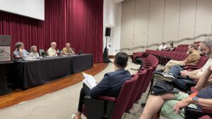
The Urrlab team, together with the Map and Data Centre of the Faculty of Science, organised a second Spatial Data Science across Languages (SDSL) workshop with more than 25 participants on-site and about the same number online.
The SDSL workshop aims to bridge the gap between the programming languages used in data science for geographical applications and bring these communities together to discuss their differences and similarities and to find ways to discuss, collaborate and synchronise efforts.
This year’s workshop continued the discussion started a year ago at the University of Münster and attracted key developers from more than 20 countries in Europe and the USA. We hope to continue next year at the University of Salzburg.
Call for applications! Students from geography, history, law, and other related fields of study from all levels are welcome to join.
Course description:
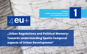
“Urban Regulations and Political Memory: Towards Understanding Spatio-Temporal Aspects of Urban Development” is an international, interdisciplinary course organised by five 4EU+ member universities: University of Warsaw, University of Milan, Charles University, Sorbonne University,Heidelberg University as part of the 4EU+ joint educational offer during the academic year 2024/2025.
Key topics of the course are the driving forces of urban changes, development of smart cities and interdisciplinary methodologies of urban studies. The course is developed as part of an educational project which addresses changes in the conditions of the urban development of smart cities in Poland, Italy, Czechia and Germany, according to three dimensions: past (history), present (law) and future (geography). Emphasis is put on integrated and interdisciplinary approach in order to help students understand the complexity of new urban centres in which real estate development must coexist with the protection of the environment and with the history and heritage of the local community.
The course will be conducted by an interdisciplinary team of historians, lawyers, geographers and educational sciences specialists.
Course dates: Wednesdays afternoons, starting from 2 October 2024 (13:15-14:45 / 13:15-15:45 / 13:15-16:30).
Language of instruction: English.
Number of online didactic hours: around 30 (lectures and workshops).
Assessment methods and conditions for obtaining credit:
Group work: producing an essay and delivering a presentation (each student group has to comprise participants from different universities). Essays will be presented at a face-to-face conference (2 days) held at the Charles University in Prague in March 2025. The best student essays could be published on the course communication platform / website or in co-authorship with the tutor in journals.
ECTS credits at Charles University: Faculty of Law 4, Faculty of Science 5. / ECTS credits atthe University of Milan: 3. (University of Milan: history –only MA students).
ECTS credits at the University of Warsaw: Faculty of Law 8, Faculty of History 4, Faculty of Geography 8 / ECTS credits atHeidelberg University: Faculty of Geography 8.
Application and selection:
The students will be selected based on their CVs and motivation letters. The deadline for sending the documents is 16 September 2024. The CV and the motivation letter should be sent as a single PDF document to unread@wpia.uw.edu.pl. The file’s name should contain the applicant’s name (surname_name.pdf), and the subject of the email should be “UNREAD+ recruitment”. The motivation letter should indicate the students’ objectives and motivations for taking the course. The motivation letter should not exceed 1,000 characters.
Check out our last year’s edition!
We are pleased to announce that a research consortium led by Dr Martin Fleischmann has been awarded a grant to study the structure of cities in Europe in space and time. The project, funded by the European Space Agency, will be carried out in collaboration with academic partners from The Alan Turing Institute, led by prof. Dani Arribas-Bel, and the OECD Geospatial Lab, led by Dr Claudia Baranzelli, and with partners from policy (The Prague Institute of Planning and Development) and practice (4ct).
During the 12 months of the project, the team will develop the the methodological basis for the development of a continental scale urban fabric classification that can be unfolded in time using artificial intelligence applied to Sentinel 2 satellite imagery.
The total value of the funding is €250,000.
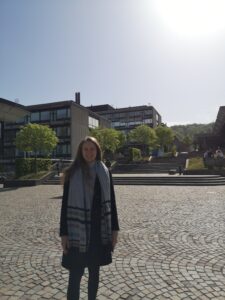
We are very happy that our team members (PhD students) gain experience abroad! A few weeks ago, Niloufar Ghafouriazar, completed a three-month doctoral internship at the University of Toronto’s Geography and Planning Department as an international visiting graduate student. She took a course on Qualitative Data Analysis and concentrated on applying grounded theory qualitative methods in urban studies under the supervision of Professor Zachary Hyde.
In the last three years, we have welcomed three new PhDs to our team. We just forgot to let you know. Congratulations to all of them, of course, and we look forward to seeing who will be the next successful PhD graduates.
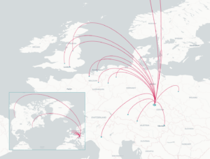
At the end of April, the Annual AAG Meeting took place in Honolulu (Hawaii). The themes of this year’s AAG connected meeting and academic offerings to the ecologies, history, and cultures of the host location in Hawai‘i, affirming the interconnectedness of place and beings here and around the world. These themes shaped keynotes and special events during the meeting. The three main themes were:
Reciprocal Scholarship
Colonialism and Resources
Recovery and Restoration
Two members of our research lab attended this year’s AAG, Jiří Nemeškal and Martin Ouředníček.
Jiří Nemeškal was part of the session “GeoAI and Deep Learning Symposium: GeoAI and Social Sensing for Human-Pandemic Dynamics” and presented a paper called “Disruption of long-term commuting development – the impact of Covid-19 on the daily mobility in the Czech Republic.”A session devoted to the new book Theory and Explanation in Geography (Wiley, 2024)
Our team member, Adela Petrovic, since February 2024, has embarked on a six-month doctoral fellowship at Social Geography and Urban Studies (SURB), University of Zurich.She is delving into the complexities of gentrification dynamics and urban transformation processes under the supervision of Professor Hanna Hilbrandt.
Don’t miss the February seminar “Urban Planning and Development – Finding the Bridge between Science and Practice”. The event is prepared in the framework of the 4EU+ Alliance by the project team Urban Regulations and Political Memory: Towards an Understanding of the Spatio-Temporal Aspects of Urban Development PLUS. The focus will be on spatial planning from different perspectives – geographical and legal – in three countries: Czechia, Italy and Poland. Karolina Wojciechowska, Martin Ouředníček and Zdeňka Havlová will be among the presenters.
Date: 21 February 2024, 13:15-14:45
Form: online
The whole programme will be in English!
More about the programme and the link to log in here.
Používáme cookies k optimalizaci našich webových stránek a našich služeb.
Funkční
Always active
The technical storage or access is strictly necessary for the legitimate purpose of enabling the use of a specific service explicitly requested by the subscriber or user, or for the sole purpose of carrying out the transmission of a communication over an electronic communications network.
Předvolby
The technical storage or access is necessary for the legitimate purpose of storing preferences that are not requested by the subscriber or user.
Statistiky
The technical storage or access that is used exclusively for statistical purposes.The technical storage or access that is used exclusively for anonymous statistical purposes. Without a subpoena, voluntary compliance on the part of your Internet Service Provider, or additional records from a third party, information stored or retrieved for this purpose alone cannot usually be used to identify you.
Marketing
The technical storage or access is required to create user profiles to send advertising, or to track the user on a website or across several websites for similar marketing purposes.
 We’d like to invite you to attend a public talk by Anastassia Vybornova from the IT University of Copenhagen on the topic of ‘Mathematics in the Ghetto’: pitfalls (and potentials) of computational approaches to urban segregation, that will happen on December 4th at the Faculty of Science.
Anastassia Vybornova (she/her) is a PhD student in Urban Data Science at IT University of Copenhagen. Her work is centered around geospatial data and applications, socioeconomic inequalities, and sustainable mobility.
We’d like to invite you to attend a public talk by Anastassia Vybornova from the IT University of Copenhagen on the topic of ‘Mathematics in the Ghetto’: pitfalls (and potentials) of computational approaches to urban segregation, that will happen on December 4th at the Faculty of Science.
Anastassia Vybornova (she/her) is a PhD student in Urban Data Science at IT University of Copenhagen. Her work is centered around geospatial data and applications, socioeconomic inequalities, and sustainable mobility.

 The Urrlab team, together with the Map and Data Centre of the Faculty of Science, organised a second Spatial Data Science across Languages (SDSL) workshop with more than 25 participants on-site and about the same number online.
The SDSL workshop aims to bridge the gap between the programming languages used in data science for geographical applications and bring these communities together to discuss their differences and similarities and to find ways to discuss, collaborate and synchronise efforts.
This year’s workshop continued the discussion started a year ago at the University of Münster and attracted key developers from more than 20 countries in Europe and the USA. We hope to continue next year at the University of Salzburg.
The Urrlab team, together with the Map and Data Centre of the Faculty of Science, organised a second Spatial Data Science across Languages (SDSL) workshop with more than 25 participants on-site and about the same number online.
The SDSL workshop aims to bridge the gap between the programming languages used in data science for geographical applications and bring these communities together to discuss their differences and similarities and to find ways to discuss, collaborate and synchronise efforts.
This year’s workshop continued the discussion started a year ago at the University of Münster and attracted key developers from more than 20 countries in Europe and the USA. We hope to continue next year at the University of Salzburg.
 We are very happy that our team members (PhD students) gain experience abroad! A few weeks ago,
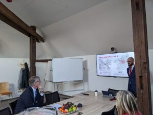
 At the end of April, the Annual AAG Meeting took place in Honolulu (Hawaii). The themes of this year’s AAG connected meeting and academic offerings to the ecologies, history, and cultures of the host location in Hawai‘i, affirming the interconnectedness of place and beings here and around the world. These themes shaped keynotes and special events during the meeting. The three main themes were: